Here is the latest storm update from the Pacific Daily News. It look like the most likely scenario is a pass slightly to the north of Guam as a weak (75mph winds) typhoon. That whole lighter colored area shows the many possibilities for how the typhoon could pass us. We will be closing up PIU this afternoon and making the campus typhoon ready so our staff and students can “enjoy” their wet and windy 4th of July weekend. Please keep praying. 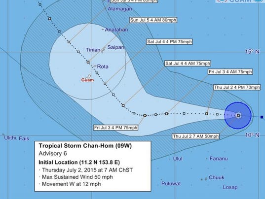
Tropical Storm Chan-hom is expected to pass through the Marianas as a typhoon over the weekend, according to the National Weather Service.
The storm is expected to pass north of Guam, close to Rota, late Saturday or early Sunday, according to the Weather Service's latest forecast graphic posted at 7 a.m. today. Maximum sustained winds are expected to be about 80 mph when the system makes its closest approach, the graphic shows.
Chan-hom is expected to bring rain and thunderstorms to Guam beginning tomorrow, and winds are expected to strengthen over the weekend, said meteorologist Brandon Aydlett.
In a release issued yesterday by Guam Homeland Security, meteorologist Chip Guard said conditions could change during the night. He said the Weather Service anticipated the storm slowing down yesterday evening and they would know more about the storm's exact track this morning.
As of 7 a.m. today, the tropical storm was positioned about 630 miles east-southeast of Guam, according to the Weather Service. The storm was moving west at 12 mph. The system had maximum sustained winds of 50 mph, with tropical storm winds extending out up to 60 miles from the center.
Chan-hom is expected to continue westward through tomorrow with a slight increase in forward speed before slowing down just southeast of the Marianas, the Weather Service said.
No comments:
Post a Comment